- Chapter 1 - Summary & acknowledgements
- Chapter 2 - The report
- Chapter 3 - Sources & materials
- Chapter 4 - Possible explanations
- 4.1 Flocking birds
- 4.2 Stratospheric balloons
- 4.3 Mirage
- Chapter 5 - Conclusions & questions
- Additional sources
- Appendix A - Weather data
- Appendix B - Witness statements extracts
- Appendix C - Similar reports
|
R e s e a r c h
T h e B O A C L a b r a d o r s i g h t i n g of J u n e 2 9, 1 9 5 4
Martin SHOUGH
Possible explanations
4.3. Mirage T he theory of an unusual mirage may appear at first glance to have fewer difficulties than either birds or balloons. Such a mirage would be formed by a layer of air in which temperature climbs rather than falls with altitude, called an inversion. These layers can occur adjacent to the earth's surface or, as in a case such as this, high in the atmosphere - a so-called elevated inversion. As is well known, if the temperature gradient within the narrow inversion layer is steep it can refract light rays through angles large enough to trap or "duct" them, and a well-developed inversion layer in a highly stable atmosphere might be hundreds of kms (or miles) in horizontal extent, forming a curved sheet approximately following the curvature of the earth. Light rays from objects far away that enter the duct (at shallow angles) can be, as it were, piped over the normal horizon to the eye of the viewer. If the eye is in, or close to, a duct such as this then remote objects (such as mountain tops for example) far below the geometrical horizon can be lifted into view and optically distorted. These shapes may appear to hover detached in the air above the horizon. Such lifted images are called superior mirages. 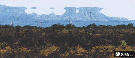
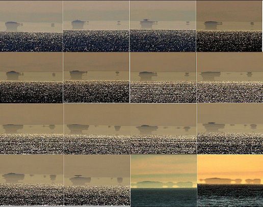
Fig. 6 : This photo was published in the January 8, 2005 edition of the Mexican newspaper El Imparcial. The following "clarifications" were given: "HERMOSILLO, Sonora(PH) - More than half of a hill located on the Hermosillo coast apparently 'vanished'. (...) According to a series of images taken by EL IMPARCIAL which were classifed as 'historically significant', a hill belonging to the Sierra de Cirios range near Puerto Libertad ceased to exist in a matter of hours. At 08:54 minutes yesterday, a reporter and a photographer from this newsroom saw what they took to be a UFO as they drove along Rt.36 North along the coastline. After this sighting there occurred a strange phenomenon in which rocky formations changed composition (sic). At 14:08 hours, as shown by photographs taken from the site, a considerable part of said hill disappeared". The Mexican paper published 3 of the 12 pictures that were taken by their photographer. The image above is the first of this series and apparently shows not one but two "UFOs". The second photo is very similar except that, according to the newspaper's commentator, "Matter begins to fall from the object on the left before it lands on the hilltop". A subsequent investigation, however, revealed that chuncks of the hillside were not swallowed up by spacecraft, but that the hills were still perfectly intact. In reality, the photos show a typical superior mirage, whereby distant mountain tops were not only stretched out vertically, but also mirrorred in the sky above. [Image found at www.ufoinfo.com; translation from Spanish: Scott CORRALES.] It is typical that the images are confined in a narrow horizontal plane, as was the case in Labrador and in both of the other similar cases mentioned, and they often have a flat top or bottom edge, which corresponds to the edge of the mirage duct. Dr. Andrew YOUNG, a mirage expert on the adjunct faculty of the Astronomy Department at San Diego State University, points out [47] that the main Labrador object swelled and changed shape at one point, interpreted as a banking approach, and assumed a shape that Capt. HOWARD thought was like a "wing" [48]. His drawing shows the appearance of a level top edge which might be interpreted as the image filling the top of the duct, after which it "flattened and stretched out" into a shape with a level bottom edge [49]. In the 1968 Australian Zanthus case of 1958 (see Appendix C Case #5), the small objects always maintained an orientation level with the horizon, as did Capt. E. J. SMITHs in the United Airlines sighting of 1947 (see Appendix C Case #1), in which case all nine narrow objects showed a flat edge on the horizion side and a rough upper profile. In the Labrador case mountainous terrain lay NW of the aircraft in the direction of the UAPs and the Sun. In the 1968 Australian case a mountainous region of South West Australia lay in the direction (NW) of both the UAPs and the sunset. In the United Airlines case of 1947, the objects once again lay in the direction of the mountains of Oregon near the setting Sun. With specific reference to the Labrador sighting, the main problems in the way of the mirage solution hitherto have been: - the objects were said to have climbed to the same apparent altitude as the aircraft after being initially sighted at a depression angle through a lower cloud deck; - the sighting geometry is extremely anisotropic; - and nature of the target object(s) being miraged is obscure because of the 19,000 ft flight altitude; 4.3.1. The climb of the objects The first problem arises from this account by Capt. HOWARD: "(...) we were crossing the St Lawrence estuary near Seven Island, Quebec. We were flying at 19,000 ft above broken cloud at possibly 14,000 ft, with the coastline clearly visible through gaps in the cloud. I then saw these objects for the first time (...) maybe 3 or 4 miles to the north west of us (...) They were below the cloud at this time, at a guess at 8,000 ft. Soon after crossing the coast into Labrador, the cloud layer was left behind and the objects were now clearly in view, seeming to have climbed more nearly to our altitude." (HOWARD, 1982) The superior mirage image should appear up near the astronomical horizon (an eye-level plane parallel to a tangent plane touching the sphere of the earth vertically below the viewer), not at a depression angle of tens of degrees, well below the geometrical Earth horizon as implied here. Types of mirage known as mock-mirages could produce images at small depression angles near the geometrical Earth horizon (in this case the dip of the GH would have been 2.4° below the AH [50]), but even then the idea of constant images being preserved through a smooth, seamless transition between two different types of viewing geometry is hard to credit. And in addition, the mock-mirage light rays would have to have been released from the top of an inversion duct below the clouds in order for these clouds to intervene in front of the mirage image. Yet the images appearing at the same apparent level as the Stratocruiser during the rest of the sighting require a duct at the aircraft altitude. So, if accurate the reported climb through low cloud makes a mirage explanation very difficult indeed [51]. Why should this 1982 account - written expressly to "put the record straight" [52] - not be accurate? Well, it does contain estimates of cloud height, object height and object range which contradict earlier accounts; however these may be considered inessential details. The sighting of the objects below lower cloud when over the St Lawrence, and their climb thereafter to the plane's altitude, are the structurally important features. And if we go back to December 1967 Capt. HOWARD was saying essentially the same thing in his Colorado Project Sighting Report form (relied upon by analyst G. David THAYER): "Soon after crossing overhead Seven Islands at 19,000 ft (...) both my copilot and I became aware of something moving along off our port beam at a lower altitude at a distance of maybe five miles, in and out of a broken layer of stratocumulus cloud. As we watched, these objects climbed above the cloud and we could now clearly see one large and six small" (THAYER, 1970; see also Appendix B). But in Capt. HOWARD's earliest, December 1954, account things were rather different: "We crossed the St. Lawrence and flew over Seven Islands [on the north bank of the St Lawrence] (...) There was low cloud at about 5,000 feet, but up where we were at 19,000 feet, cruising along at about 270 miles per hour, it was perfectly clear [53]. The sun was just beginning to set, away to the left. At that height there is very little coloured tint on account of the rarefied atmosphere. The sky was almost silver in its clearness - perfect visibility. It was 9.05 p.m. Labrador time and we were about twenty minutes' flying time north-east of Seven Islands when I first sighted the thing" (emphasis added, HOWARD, 1954). According to HOWARD's 1982 account the objects were seen low and through the cloud for a significant time before the Centaurus had crossed the the St Lawrence, whilst heading NE with the north shore "clearly visible" ahead. In 1967 he said the sighting had commenced "soon after" passing Seven Islands, i.e. after crossing the north shore, but still (it is implied) not too far inland from Seven Islands - an implication reinforced by his listing of "small airport at Seven islands, harbour works etc" as landmarks in the vicinity of the sighting (HOWARD, 1967). So these accounts are arguably at least somewhat consistent [54]. But according to the earliest complete account by Capt. HOWARD himself, and endorsed by him (prior to December 1967) as a "faithful and accurate record" (see Chapter 3, note [4]), the sighting did not even start until 20 mins after the plane had crossed the north shore into Labrador: "(...) we were about twenty minutes' flying time north-east of Seven Islands when I first sighted the thing". Assuming a ground speed of ~270 mph (= 265 mph reported True Airspeed plus "not much of a following wind" [55]) this puts the plane at least 90 miles NE of Seven Islands, but even HOWARD's recollected "twenty minutes" is probably an underestimate. The USAF telex from Goose gives the initial aircraft position as "5153N 6310W". This position fits exactly the statement by Capt. HOWARD quoted widely in the press on July 1 and 2, 1954 and logged in his contemporaneous 'Voyage Report' (see Appendix B) that they were 150 miles SW of Goose when they saw the objects, and his own early narrative placing the end of the sighting about 20 mins flight time SW of Goose. The position is about 180 miles or fully 40 minutes flying time NE of Seven islands [56]. But in any case, the first glimpse of the objects was clearly many tens of miles and several tens of minutes after crossing the coast, not whilst still flying over the St Lawrence. And in the original 1954 scenario there was no mention of having seen the objects below them, through cloud. Indeed Capt. HOWARD's simile for his very first glimpse was "bursts of flak" suspended in the perfectly clear sky and his Sketch #1 drawn in his Flying Logbook in real time (Fig. 1) and showing the shape of the main object as he said it appeared "at first glance" (an inverted flat-topped "pear" flanked by smaller blobs) puts the object at the same elevation above the horizon as do his Sketch #2 and Sketch #3 illustrating the later stages. Consistent with this, an Associated Press wire story [57] the very next day quoted Capt. HOWARD as saying that these flak-like objects "flashed into sight suddenly" which can be interpreted as expressly contradicting much later accounts in which they were first intermittently "glimpsed" or "become aware of" through gaps in low cloud. All other contemporaneous reports known to this author either explicitly support this interpretation or are not inconsistent with it. For another example, a US radio news broadcast claimed to quote "the official report signed by every member of the eleven-man crew" as follows: "We were flying at 19,000 feet about 280 mph over Labrador. It was just after sunset (...) a beautiful clear evening. Against the western sky we saw before us the silhouettes of a large black object with six much smaller objects clustered around it" (emphasis added) [58]. Press quotes cannot be relied upon as primary sources, but it might be thought significant that whilst all press and newsreel sources can be interpreted consistently with a narrative in which the objects first appeared as silhouettes apparently co-altitudinal with the aircraft, not one known contemporary account exists which even hints that the objects climbed from below clouds. Further corroboration comes from Capt. HOWARD's own description in a BBC TV interview broadcast on July 2, 1954, only two days after the event [59] in which he states that "the Sun had just set" when the objects were first sighted. Early newspaper accounts also quote HOWARD to the same effect: "The sun had just set, and the nearest cloud was many thousands of feet below" (emphasis added) [60]. The December 11, 1954 magazine account which Capt. HOWARD himself endorsed as being "the most faithful and accurate record" reinforces the point: As they crossed the north shore of the St Lawrence near Seven Islands "the sun was just beginning to set" (emphasis added), then later "we were about 20 mins flying time NE of Seven Islands when I first sighted the thing." HOWARD's contemporaneous Logbook drawings agree (Fig. 1), showing the final segment of the Sun setting in Sketch #1 of 3. The recorded time (01:05 Z) would be correct for the reported "just after sunset" at 19,000 ft above the officially recorded map coordinates (position 150 miles SW of Goose). But over the St Lawrence, 40 minutes earlier at 00:25 Z and ~70 miles further West, the Sun's lower limb would still have been about two solar diameters clear of the horizon [61]. Clearly the data are fully consistent only with the primary 1954 account(s) [62]. Finally, just as this report was on the point of completion, the author finally managed to obtain a copy of the November, 1954 FATE article [63] quoting directly from Capt. HOWARD's own "Voyage Report" written whilst still in the air en route to London. The opening paragraph reads as follows: "At 0105 GMT today (June 30) about 150 nautical miles southwest of Goose Bay, height 19,000 feet, flying in clear weather above a layer of low stratus cloud, I noticed on our port beam a number of dark objects at approximately the same altitude as our aircraft" (CARNELL, 1954; see Appendix B). This seems to prove rather conclusively that the climbing of the objects from below cloud over the St Lawrence was a later embroidery by Capt. HOWARD. And given this, even the weaker claim of a slight increase in elevation to about 8° above the horizontal towards the end of the sighting (made in his 1967 University of Colorado UFO Sighting Report) must be in very serious doubt [64]. One might speculate that with time for mature reflection during the years between 1954 and 1967 Capt. HOWARD came to see his early forthright rejection of the mirage theory as ill-advised and was thus unconcsiously motivated to adapt his recollection a little.
Fig 7. Superior mirage images of the Fata Morgana type showing the Farallon Islands off the coast of San Francisco, photographed over the course of several hours by Mila ZINKOVA. [en.wikipedia.org] 4.3.2. The anisotropy of the images The second main problem with the mirage theory relates to the fact that the images appeared over a very restricted sector at about the same bearing from the aircraft for the whole 18 minutes or 90 miles of travel. Because elevated inversion ducts in the free atmosphere are widespread thin sheets that don't have any appreciable horizontal structure (only vertical structure) one says that they are isotropic, or have the same optical properties in all compass directions for an observer inside them. In 1968 THAYER speculated that it might be possible to avoid this limitation of the natural mirage theory if the plane was flying through a layer of barely sub-critical refractive index gradient which was pushed over locally into a mirage-producing gradient by the compression shock wave of the aircraft's own passage through the air. In other words, the plane might have been creating its own atmospheric "lens" in the immediate region ahead of the wing - where the images were located. However, Andy YOUNG points out that this was a slow subsonic airliner and believes that the compression shock could not conceivably have been sufficient to cause this effect [65] This idea was also received with great scepticism by atmospheric physicist James E. McDONALD [66]. So there is no purely optical reason why one restricted sector of the compass should so persistently contain these mirages whilst other sectors in other directions do not, inviting instead a geophysical or other reason. In more typical circumstances mirages are seen with the eye near ground- or sea-level so that both the eye and a target object at the surface, such as a ship or an island, are found within the same horizontal inversion layer. A fine example of such a superior mirage is shown in Fig. 7. In this case the target is the Farallon Islands off the coast of California, a group of small islands and sea rocks about 27 miles from San Francisco. In conditions of normal refractivity they are entirely beyond the visual horizon from the sea-level camera position [67] but a surface inversion has ducted the light rays around the curve of the Earth. When compared with the BOAC observation the effect seems suggestive, but as Capt HOWARD put it at the time: "It has been suggested that what we saw was no more than a mirage. But at 19,000 feet, a mirage of what?" (HOWARD 1954).
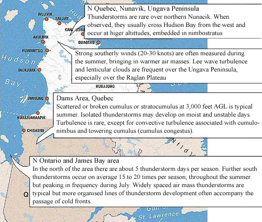
Fig. 8 : Significant summer weather patterns along the east Hudson Bay coast area, based on information in NAVCANADA's Local Area Weather Manual, Ontario & Quebec, Chapter 3 [www.navcanada.ca] 4.3.3. The nature of the target objects The third objection is that because of the shallow grazing angle requirements for entry to and exit from the duct, light rays cannot rise steeply from the Earth's surface into the duct, which for a duct at around 19,000 ft means that target objects on Earth's surface - one immediately thinks of silhouetted mountain peaks in the rugged terrain of Quebec - would need to be at enormous distance. Great distance is already implied by the constancy of the sighting bearing, but it is concerning that these objects were reportedly very dark, almost black, with high contrast against the bright sky, which would not be expected if the miraged peaks were at very great distance. Image contrast suffers already for objects miraged via long ducts because of sunlight scattering from air molecules and aerosols in the duct. This "fill-in" causes dark targets to yield progressively paler mirage images the longer the raypath through the duct. And if the objects imaged are surface features at enormous distance beyond the point where the rays couple into the duct then contrast must suffer further. Firstly, this is because landscape hundreds of miles beyond the apparent Earth horizon at local sunset will still be in full sun with minimal silhouetting and with shadows washed out by back-scattering from the still-bright sky. And secondly there is a already a large loss of contrast due to scattering on the long ray path through the dense lower troposphere from the mountain to the elevated duct. It is also noteworthy that if one plots the Stratocruiser flight path on Google Earth and explores the terrain elevation to the NW, whilst the landscape is rugged much of the way to Hudson's Bay with elevations generally ranging between about 1,000 and 2,000 ft, only a few isolated ridges exceed 3,000 ft. No especially prominent range of peaks stands out. Indeed beyond about 300 miles from the flight track the landscape prominence diminishes, and we already know that to keep parallax displacement within 10° or so we need a range from the flight track approaching 400 miles. There are no tall mountains here, only rugged hill country up to about 1,000 ft, dipping towards coastal lowlands. In the course of correspondence with Dr. Andy YOUNG during summer 2009 an interpretation emerged that may solve some or all of the remaining problems of the mirage theory. Rather than enormously remote mountains the miraged objects may have been silhouetted high-altitude clouds, either lines of towering cumulus (cumulus congestus) which are sometimes known to punch up through an inversion layer [68] (often over 20,000 ft, sometimes to 30,000 ft or more), more fully-developed cumulonimbus storm anvils (even higher and perhaps miles wide, the sort of scale implied by the reported angular width) or alternatively perhaps well-defined orographic clouds (standing-wave lenticular clouds, sometimes called mountain clouds) forming thousands of feet above the peaks. In what follows the reader may refer to the local weather information in Fig. 8. One relevant reference frequently cited in the mirage literature is a superior mirage of a cumulus cloudtop observed from an aircraft at high altitude in 1956. The authors remark: "Such phenomena as described in this paper do not appear to have been previously reported from aircraft in flight, unless some of the reports of 'flying saucers' may have been due to this effect." (DURST & BULL, 1956) Clearly observations of this type are relatively unusual, but a few reliable records including high-altitude observations of "green flash" mirages [69] "certainly suffice to show that strong inversions can occur at rather large heights in the troposphere. So mirages at aircraft heights are uncommon mainly because of a lack of objects at suitable heights to appear miraged." [70] In investigating the likelihood of an extensive, strong, high-level inversion over Eastern Canada on the sighting date we are unfortunately reduced to inference. First of all, the basic continental synoptic situation described in the Monthly Weather Review for June 1954 [71] is the unusual presence that month of dominating high pressure centred on Labrador, displacing the usual Canadian low-pressure cyclone. This high was present both at sea level (with average pressure for the month 4 mbar above a >10-year normal in the sighting area) and at the 700 mbar level (~10,000ft) where a large positive pressure-height anomaly of 260 ft [Appendix A (xi)] marks the centre of a slow-moving "blocking high" over Labrador, a situation controlling much of the weather over the Eastern continental US during the month, contributing to heatwaves, drought and unusual weather fronts. For the day in question, US Weather Bureau Daily Weather Maps with limited coverage of NE Canada [Appendix A (viii)] indicate a high off the Labrador coast and sea level pressure of >1020 mbar over the sighting area [72]. Consistently, the Goose AFB weather report telexed just after the sighting time (but relating to an unspecified observation time) shows a surface atmospheric pressure NE of the sighting location of 30.13 inches of mercury, equivalent to 1020.32 mbar, which is unusually high [73], and the Goose A Hourly Data Report shows temperature still over 20°C at 9:00 p.m. local time that evening [see Appendix A (vii)]. The only weather reports northwest of the flight track (Appendices A.iii-iv) also show an unusually warm afternoon. Winds SW of the sighting area were light easterly; NNW of the sighting area they were light southerly, following an anticyclonic circulation around the high pressure field centred off the northeast of Labrador. An anticyclonic temperature inversion under a stable high is the type of inversion normally most likely to lead to a low-level mirage duct of large horizontal extent (as indicated in a report by Navy icebreaker USS EDISTO; see Chapter 3). As for more important upper levels, the US Weather Bureau chart of the 500 mbar pressure surface [Appendix A (ix)] based on radiosonde ascents made between 10 and 11 p.m. EST (just after the sighting time) shows the air temperature over Newfoundland at ~19,000 ft as -10°C, which, as expected from the presence of measured high pressure through at least the first 10,000 ft of the atmosphere, is abnormally warm. The ICAO international standard atmosphere (ISA) has an average temperature lapse rate of 6.49°C/1,000 m (1.98 °C/1,000 ft) which would indicate -18°C at 19,000 ft above a sea level temperature of 20°C. Unfortunately we have no direct evidence of upper-air temperature gradients. It's true of course that cumulus or cumulonimbus development signifies vertical instability, not stability, and would be inconsistent with these stable, anticyclonic conditions near the sighting area. MCDONALD (1968) rejected the mirage theory at least in part because of the absence of appropriate high-altitude targets such as clouds, remarking that the fair weather situation and observer reports did not indicate the presence of clouds. But by 1969, following the publication of Thayer's analysis in the Condon Report, MCDONALD appears to have realised that a mirage of horizon cloudtops needed to be considered, as disclosed between the lines of his letter to Capt HOWARD in which he noted that local weather conditions didn't indicate the likelihood of cloud tops rising to 18,000 ft or more and emphasised repeatedly that it was important for HOWARD to be able to confirm the absence of high clouds (MCDONALD 1969). HOWARD had indeed done this. But the hypothetical cloud concerned would be far away over the hills of N Quebec, perhaps 400 miles or more distant and thus beyond the geometric horizon. Fully-developed thunderstorm systems tend to track in across Hudson Bay from the west. According to a study of thunderstorm activity in the west Hudson's Bay area "the convective storm season (...) [is] short but intense with a strong peak (...) during June and July" [74] but they only infrequently reach N Quebec. However towering cumulus can be triggered by mountain updrafts, and wave clouds are also caused directly by mountain winds.
Well-developed lenticular clouds do in fact require just the sort of sandwich structure of atmospheric layers that often occurs with an elevated temperature inversion. The second requirement is a stiff wind at the height of the mountain barrier. They commonly form in linear groups within a succession of wave-crests downwind from a hill or mountain area, sometimes many thousands of feet above the peaks and perhaps many miles downwind. The problem as already mentioned is that the landscape prominence at a useful range from the Stratocruiser is not great. The NavCanada local weather information summarised in Fig. 8 indicates the prevalence of lenticularis over the Raglan Plateau, at the tip of the Ungava Peninsula, but this is a low upland terrain no more than about 460 m ASL (1,500 ft) and the wave clouds form typically at only 6,000-7,000 ft. It is also some 300° north of the visual bearing to the UAPs, which was closely limited on the north by the nearby sunset. Moreover the 20-30 kt summer winds that cause the Ungava lenticularis blow rather uniformly from the SW and cause wave clouds to plume in a NE direction, increasing the mismatch with the visual bearing. Sporadic lenticularis does occur due to isolated hills at some coastal sites further south along the Hudson Bay coast, and inland. But everywhere at the required range the relief is lower than the Raglan Plateau [75]. 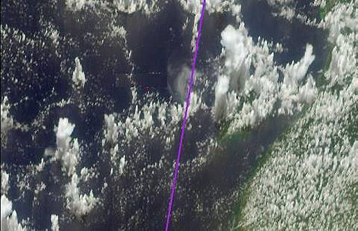
Fig. 9 : Jet Propulsion Laboratory satellite image of a line of towering cumulus plumes photographed from a high angle. A 3-D animation at the site photojournal.jpl.nasa.gov shows well the extreme vertical development up to tens of thousands of feet (the purple line shows an aircraft track and is not relevant) Unfortunately, no detailed winds aloft data for June 29, 1954 over Quebec are available. But at least some general weather data are archived by the Canadian Weather Office [76]. Hourly data reports are available for Kuujjuaq on the far north coast and Sept Iles, nearby to the SW on the St Lawrence coast. The most nearly relevant is Kuujjuaq, 400 miles NNW of the Centaurus' flight track and somewhat N of the line of sight but possibly indicative of conditions in the area. Kuujjuaq had cloud much of the day, with temperature climbing to a high of 26.7 °C in the early afternoon. This was the warmest day in a fortnight, well over the almanac average daily maximum of 15.3 °C, with a 5 kt "slight breeze" (Beaufort 2) from the South. Relative humidity climbed from a low of 35% in early afternoon to 84% by early evening, with the onset of rain. These calm, warm, humid conditions, if representative, do not strongly indicate unusual lenticularis but are at least not inconsistent with mountain-triggered convective cumulonimbus or cumulus congestus in the sighting direction. (The available data are tabulated at Appendix A) Another possible cause of towering cumulus is convective instability due to an off-shore evening breeze front over coastal waters. According to meteorologist Roger EDWARDS: "In weak large-scale low level flow, as the land cools faster than the water, dense and relatively cool air flows seaward late at night and near sunrise. Lift along the edge of this land-breeze front forms convective clouds (...) which can become strong thunderstorms if there is even more lift and/or instability. (...) lift along the land-breeze front is usually strongest when the low level winds [blow] directly toward the front" [77]. There is some evidence of a high pressure dome over the sighting area, possibly shedding a southeasterly isobaric wind towards the Hudson's Bay coast, which might be consistent with conditions for humid convection along a land-breeze front [78]. The raypaths from high clouds do not have to pass through the dense and hazy lower atmosphere but instead originate and remain within the duct, minimising contrast losses. Because the target is already within the duct, or at the duct altitude, it also does not have to be so far beyond the apparent Earth horizon (as would a target on the Earth's surface), and therefore can be closer to the sunset terminator where a dark backlit silhouette is more likely. 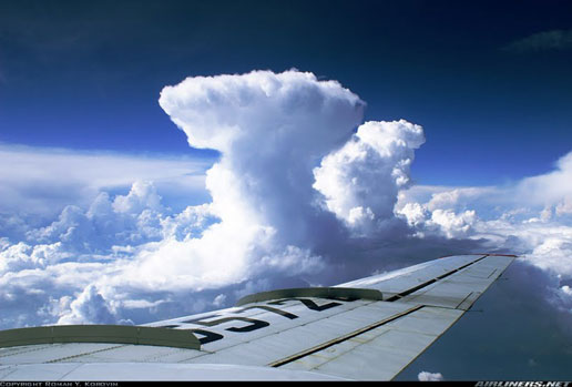
Fig. 10 : Superb photo of a line of spectacular towering cumulus takenfrom a Tupolev-134 in June 2007. [© Roman Y. KOROVIN - image found on picasaweb.google.com] There may have been rather special viewing conditions in this case (and related cases) that would help mirages of clouds to appear as black shapes with high contrast against the bright sky by minimising the "fill-in" due to Rayleigh scattering of sunlight by air molecules in the duct. As mentioned, at sea level the optical depth of the atmosphere dramatically reduces contrast in mirages, but at 19,000 ft the air density is less than half the sea-level value and there are few aerosol particles. Moreover, as Andy YOUNG points out, with the Sun partly or completely set at the Stratocruiser's altitude this means that much of the elevated duct would be in partial or complete shadow during the sighting (see Fig. 11). Loss of contrast caused by 'fill-in' (washing out or greying due to background scattering by particles in the duct) would thus be minimised along the path of ray B for these near-sunset mirages. We get the source silhouette from the effects that routinely make low clouds look blackish against the sunset - in part atmospheric extinction reducing the intensity of low sunlight backlighting the cloud, and in part because near sunset the front illumination of the cloud by ambient scattered sky brightness is negligible. These effects, along with the 'normalising' effect of the human eye-brain that learns to see the lightest tone in the visual field as its "reference white" and the darkest as its "reference black", explain the existence of a high-contrast source image to start with. Whilst preservation of the contrast in the mirage image would be aided by the shadowed duct which prevents fogging or fill-in of the dark areas, the ducting itself is of course not lossless because of leakage and extinction, and so the image loses overall brightness compared with the original scene. The effect of this might well be that the brightness of the more westerly sky imaged in the mirage strip is dimmed to match the lower ambient sky brightness at the viewing location, whilst the cloud darkness in the mirage strip becomes still darker. 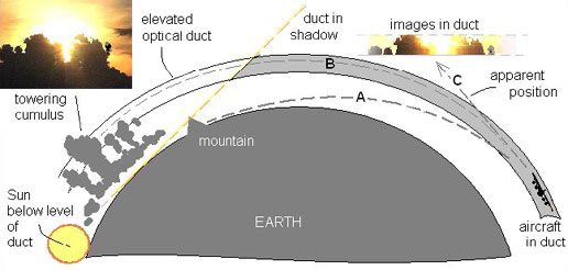
Fig. 11 : Highly schematic diagram of possible mirage geometry. The high contrast possible for ducted mirages of high clouds is less likely for mountain peaks, because in the former case the image source can be in the 19,000 ft elevated duct, not <15 kft below it as Quebec mountain tops [79] would be. The ray from a relatively nearby mountain a couple of hundred miles away or less (e.g., ray A in Fig. 11) not only has to pass through the scattering thickness of the lower atmosphere, incurring extinction and loss of contrast, but also intercepts the duct at an excessively steep angle of 1° or more [80]. The long, shallow grazing incidence required for rays from a mountain to couple into the duct means that the mountain must be much further away than a cloud need be, and being at much greater range (much further west, where significant peaks are in fact not to be found) it is being imaged longer before local sunset and is subject to more front illumination from scattered sky brightness, so has a lower original contrast. Similar viewing conditions appear to have obtained in the 1947 United Airlines sighting and the 1968 Australian observation already mentioned [81]. In both of these cases the aircraft were lower at only ~8,000 ft, where fill-in due to scattering would be greater than in the Labrador case; but the Sun was in both cases well below the horizon at the sighting time, with all or most of the hypothetical mirage duct being in shadow, again favouring good optical contrast, as reported. The length of the BOAC Centaurus observation in particular (18 minutes) is certainly great and an inversion duct of large horizontal extent is also implied by this fact. Because such mirage ducts are very shallow - typically only tens of metres, or a couple of hundred metres in the most extreme cases - it might be thought very fortuitous that the Stratocruiser remained inside the duct for so long. But as Andy YOUNG points out, the plane was flying on autopilot at the time which means that it is locked to the FL190 pressure level, and this guarantees that the plane will stay within the duct. The disappearance of the objects might have occurred because the aircraft reached a point where the duct broke down. Or perhaps the cumulus tops sank below the duct, which might fit the time and duration of the observation. The convection that drives cumulus tends to die out near sunset. The tall cumulonimbus towers, reaching tens of thousands of feet, typically survive about an hour or so [82]. Another possible objection to the mirage theory is that rays from the setting Sun must have passed close to the rays from the target (clouds). Yet apparently no distortion of the adjacent Sun was observed, either when a ~1/8 Sun was visible simultaneously with the UAPs at the start of the sighting, or indeed when the Sun would have been higher on the Earth (apparent) horizon before the objects were seen. There are two different answers to this objection. At the sighting time the mirage image (ex hypothesi) is at the astronomical horizon, which is 2.4° above the geometrical earth horizon [83], and thus well clear of the Sun [84], which cannot shine into the duct (or put another way, its rays intersect the duct at an angle too steep to be noticeably refracted by it) and thus shows no mirage distortion. Prior to the sighting when the Sun was a couple of degrees higher and passing through the astronomical horizon it might have been possible to see the Sun's disc bisected by the duct (assuming it to have been well-developed by this time), in which case the presence of the duct could be detected [85]. If the Sun is shining into the open end of the duct its rays would suffer refractive distortion, but this is unusual. More likely is that the duct's presence would be betrayed in principle by the presence of a dim band called Wegener's Blank Strip, a narrow zone lying along the astronomical horizon from which light rays coming from astronomical sources beyond the atmosphere are excluded by the duct. However, in the "perfectly clear" air at 19,000 ft the Sun would still be painfully bright to look at when it crossed the Blank Strip. By the time the sun was sufficiently dim to look at easily, it would have passed below the distorting zone of the duct. For these reasons Andy YOUNG is "not surprised that no distortions of the Sun were reported" [86].
Notes & references
[47] Personal communication, March 4, 2009. [48] Wim VAN UTRECHT comments (personal communication, September 12, 2009) that "a Northrop flying wing [YB-49] escorted by smaller planes would have been a great candidate (considering the captain's own reference to 'a giant flying wing'). Unfortunately, the last of the Northrop flying wings was dismantled in 1953". Indeed, and given the observed angular size a YB-49 or similar would be in the order of 1 mile distant or less. This is an extremely close approach in aviation terms and planes would normally be identifiable with perfect clarity. Mirage distortion is not a helpful theory when the target object is so nearby. Also, such proximity would be inconsistent with failure of radars on the ground and on the intercepting F-94 to detect the UAP(s) (see Chapter 5). [49] Wim VAN UTRECHT points out that this "level top edge" does not appear in the sketch that Capt. HOWARD made during his BBC interview of July 2, 1954. This drawing, which appears towards the end of the interview, shows an asymmetric arrow-shape, with the tip of the arrow pointing obliquely upward. This is true, but the sketch was done for the camera four days after the sighting, when the concept of a "flying wing" had had the chance to become embedded in his mental imagery. The corresponding drawing originally done in the cockpit on June 29 does show the straight top edge of the "arrow" or wing shape as approximately level with the horizon. But it's a minor point, just another instance of an overall pattern of horizontal symmetry that would be typical of a mirage duct. Wim adds another comment on this BBC interview: It begins with the mention that the sighting took place "on the day of the eclipse of the Sun", which is potentially confusing since the eclipse occurred the day after, namely on June 30, at 12:48 U.T. Dr. Ronny BLOMME, astrophysicist of the Royal Observatory of Belgium, points out that "it depends on the time zone you use. In Canadian time, the sighting occurred in the evening, but in UT it was already June 30. Probably that's what the BBC went along with" (personal communication to Wim VAN UTRECHT, July 7, 2009). [50] Personal communication from Dr. Ronny BLOMME, Royal Observatory of Belgium, August 23, 2009. [51] One may object that THAYER (1970) somewhat glossed over this issue, asserting that the images were "always within a few degrees of a horizontal plane containing the aircraft, thus satisfying the small angle requirement [for mirage]" but this feature was undoubtedly one reason for his ambivalence towards the mirage theory. McDONALD, in a letter to Capt. HOWARD seeking answers to questions for a "scientific rebuttal" of THAYER's analysis in the Condon Report, acknowledged the central importance of the angular ascent for a mirage theory and pointed out that "only if the tops of the clouds (...) were less than 1,000 or 2,000 ft below your flight altitude would the dip-angle be small enough" (McDONALD, 1969). [52] Contradictions in FSR Editor Charles BOWEN's editorial leader describing the case in Vol. 27, No. 3 were criticised in a letter from US researcher Herbert TAYLOR, published in FSR Vol. 27, No. 6, prompting BOWEN to approach Capt. HOWARD for a "correct version of the case" which was published in the same issue. [53] The description of low cloud at 5,000 ft near Seven Islands is consistent with the Sept Iles (Seven Islands) hourly weather data [Appendix A(i)], according to which it had been cloudy all day, with relative humidity over 90% since mid afternoon and rising to 100% by 21:00 Z, drizzle from 18:00 Z and fog an hour later. Drizzle is a very fine sprinkle of small droplets originating from a layer of low and thus relatively shallow cloud, generally stratus below about 8,000 ft, where the droplets' journey through the layer is not long enough for many collisions to form large aggregate drops. Fog is essentially ground-level stratus. A Beaufort 3 breeze from the East would advect warmer, moist air from the Gulf of St Lawrence over land subject to evening cooling, so a mix of advection fog and radiation fog occurs which in effect brings the bottom edge of the low stratus down to ground level. In one source (THAYER, 1970) Capt. HOWARD describes the low cloud as broken stratocumulus. This dull grey cloud is related to stratus and occurs at the same height (>8,000 ft) as stratus. Both indicate the likelihood of drizzle below and dry, stable air above, the latter being consistent with Capt. HOWARD's report of exceptionally good visibility above the cloud (atmospheric extinction is strongly negatively correlated to humidity because hygroscopic aerosols are swollen by absorption of moisture). [54] But only somewhat. HOWARD's 1967 statement gives the initial depression angle to the objects as 8° and the range as "maybe five miles" or "3 miles minimum" and the objects' height (in or below the "3/8 St Cu") as "perhaps 10,000 ft lower" (i.e., at 9,000 ft). The implied depression angle here (cos. alt/slant distance) is in the range 22° to 39°. His 1954 estimate of the cloud height (and therefore the max initial object height) was 5,000 ft. This original lower estimate, which arguably fits better the characteristic height of stratocumulus (below 8,000 ft) and the report of drizzle at Seven Islands [Appendix A(i)], leads to a depression angle for the same distances in the range 32° to 62°. The overall mean of all these implied angles is nearly 40°, five times Capt. HOWARD's explicit estimate in 1967, and explicit angular judgments are almost universally overestimated in recollection, not underestimated. Given the complete absence of a hint of any ascent at all in early sources one suspects a reluctance on Capt. HOWARD's part to draw attention to how large is the implied angular ascent in his augmented 1967 account - even despite his having doubled the cloud height to minimise it. By 1982 HOWARD had increased the cloud height to "possibly 14,000 ft" with the objects 3-4 miles away below the cloud, shrinking the implied depression angle to possibly as little as 15°, still twice his explicit estimate. [55] HOWARD's recollection. Surface winds at three locations that evening were: Seven Islands E 11 kt; Goose AFB NNW 8 kt; Kuujjuaq S 5 kt (see Appendix A), but the times are not necessarily appropriate or even known, and relevance to winds at 19,000 ft is almost nil. [56] There is no way to recover Capt. HOWARD's estimated "twenty minutes from Seven Islands" from the documented figures. We could slightly reduce the discrepancy if we were to assume that the given position marks not the start of the sighting proper but the time of the radio report logged at 01:09 Z, four minutes after the start of the sighting (cf. an ambiguously worded report in the London Times, July 1, 1954: "Captain HOWARD radioed to Goose Bay, Labrador, that he had sighted the objects at about 150 nautical miles southwest of Goose Bay"). But this merely introduces a 4-minute inconsistency at the end of the sighting - which would become 24 minutes from Goose instead of the recorded "20 minutes from Goose" - without helping significantly. [57] e.g., "Flying Jellyfish Tailed Plane, Crewmen Report", New York Telegram & Sun, Thursday July 1, 1954. [58] MBS (Mutual Broadcasting System) broadcast by Frank EDWARDS, July 1, 1954 (typed transcript in Colorado University UFO Project file; Library of the APS, Philadelphia). This original signed source is unidentified. [59] Most complete (but poor video and bad sound synch) is at www.youtube.com. [60] "Now Flying Jellyfish Zoom In", London Daily Mail, July 1, 1954. [61] From 19,000 ft the visual line of sight would be tangent to the earth about 147 NM away, equivalent to about 2.4° of longitude (the same as the altitude of the astronomical horizon), so the sunset time at 19,000 ft will be the same as the sea -level sunset where the LOS cuts the line of longitude 2.4° W of the sighting coordinates (51°53'N 63°10'W, autopilot setting 49° True, instant heading 49±5°; see Fig. 2). Working from that we get an equivalent longitude around 65°34'W and a sunset time of 00:49 Z. By 01:05 Z the upper limb of the Sun would be over 2° below the horizon so it had indeed "just set". In fact about 1/8 of the Sun is shown above the horizon in Capt. HOWARD's 1954 sketch #1 of Fig. 1 and the Sun is not shown at all in his later sketches (a segment of the solar disc 1/16° deep would disappear completely below the horizon in less than a minute). But it does appear that Capt. HOWARD's drawing of the vanishing Sun should be taken as illustrative rather than exact. The Sun had in fact, as he stated vocally and in writing, already "just set". [62] It is interesting to see that in later accounts when the action had been shifted 150 miles and 40 minutes to the vicinity of Sept Iles, Capt. HOWARD adjusted the position of the sun accordingly. In 1967 the first sighting was no longer "just after sunset" as stated in 1954, rather the "later" parts of the sighting occurred "just before and just after sunset". By the 1982 version the Sun was still "at this time (...) low in the northwest" after the objects had been seen climbing through cloud up into the clear sky, and it was not until nearly 18 minutes after the initial sighting, when the F-94 was approaching, that "at about this time the Sun set in the northwest". [63] Thanks are due both to Claude MAUGÉ and to Herbert TAYLOR for locating this source. [64] It's worth noting that there are anomalous accounts of increasing angular elevation in spectacular mirages. Mirage expert Andy YOUNG's fascinating bibliography at mintaka.sdsu.edu contains this account of G. M. GIOVENE's observation on February 9, 1790: "I thought I saw some clouds rising in the western part just along the horizon, which occupied about 20 degrees of the same. I determined to try to observe their path, with only the idea of being able to predict which way the wind would blow the next day, and consequently what could be the state of the air, which, as I found myself in the countryside, interested me. In fact, I observed that the supposed clouds rose more and more above the horizon until they had ascended about two degrees [probably an exaggeration, as Andy Young points out]. But suddenly they began to take various shapes, so that finally I realized they were quite different from clouds..." From "Discorso meteorologico-campestre su l'anno 1790 del Sig. Don Giuseppe Giovene, Canonico della Cattedrale di Molfetta", Opuscoli Scelti sulle Scienze e sulle Arti, Parte I, Vol. 14, 3-21 (1791). [65] Personal communication, March 1, 2009. [66] McDONALD, J. E., letter to Capt. James HOWARD, January 29, 1969. [67] Only the tip of the highest island, at 360 ft ASL (109 m), would barely touch the horizon for an eye height of ~3 m ASL. [68] This type of cumulus tower is sometimes called a "chimney cloud" or "turkey neck", developing an especially narrow form when the convection has locally penetrated the floor of an inversion and rises into moister air where evaporation is inhibited. amsglossary.allenpress.com [69] e.g. TAYLOR, J. H., & MATTHIAS, B. T., "Green flash from high altitude", Nature, 222, 157 (1969). [70] Andy YOUNG, personal communication, March 1, 2009. [71] HOLLAND, J. Z., "The Weather and Circulation of June 1954; Illustrating the Birth and Growth of a Continental Anticyclone", Monthly Weather Review, June 1954, pp. 163-171. (docs.lib.noaa.gov). [72] docs.lib.noaa.gov/...daily_weather_maps - thanks to Roberto LABANTI for this and the previous source (HOLLAND, 1954) [73] Especially if (as is almost certainly the case) this is uncorrected station pressure, which would need to be adjusted upward slightly to give sea-level pressure. Average global sea level pressure is significantly lower than 1020 mbar, at 1013 mbar, and a semi-permanent summer low pressure centre to the north of the area (around Hudson Strait) means that the Goose Bay local sea level pressure tends to be significantly lower then the global value with a July average of just 1008 mbar (NAVCANADA Local Area Weather Manual, Ontario & Quebec, Chapter 3, "Weather Patterns", p. 14, www.navcanada.ca/.../3-OQ33E.PDF). [74] KOCHTUBAJDA, B., et al., "The Nature and Impacts of Thunderstorms in a Northern Climate" in Cold Region Atmospheric and Hydrologic Studies. The Mackenzie GEWEX Experience, Springer, Berlin, 2008, pp. 383-402, www.springerlink.com. [75] See also: www.navcanada.ca/.../4-N3637E.PDF. [76] Thanks to Dr. Ronny BLOMME for locating these records at www.weatheroffice.gc.ca. [78] The surface pressure maps for the 12 hours after 1:30 pm June 29 [Appendix A(viii)] show a stationary front between cold and warm air masses lying over the South of Hudson Bay. Such a front is generally associated with cloud and precipitation and can also be a location of 'storm trains', multiple thunderstorm cells that track linearly along the front. en.wikipedia.org/wiki/Stationary_front [79] Or indeed other surface targets such as the chains of islands in Hudson Bay. Cfr. also Chapter 5. [80] SNELL's Law of refraction tells us that a grazing incidence of 0.5° is becoming marginal for efficient coupling into a mirage duct with a trapping radius of curvature (33 arcsec/km) equal to the curvature of the Earth. [81] Another relevant clue in the Australian case is that the aircraft lost radio communication with ATC shortly after the start of the sighting. The signal turned to hash. The signal was regained at about the same time as the objects vanished visually. If connected this suggests a radio duct, or rather that VHF didn't penetrate into the optical duct. Radio wavelengths can be miraged too, although normally in the lower atmosphere the major contributor to refraction at radio wavelengths is humidity, which is a negligible factor at optical wavelengths. Commonly, therefore, the onset of (or termination of) ducting for VHF would not be simultaneous with the onset of ducting for light waves. But humidity typically decreases with altitude. Possibly at 8,000 ft over the deserts of SW Australia even in August the air was very dry, and both optical and radio wavelengths were similarly refracted (to within a few percent) solely by the temperature gradient of the duct. [82] "30 min to 2 hours", daac.gsfc.nasa.gov. [83] Confirmed by Dr. Ronny BLOMME, Royal Observatory of Belgium, personal communication, August 23, 2009. [84] Capt. HOWARD's drawing seems to show the sun only around 0.5° or less below the line of objects, but the relative size of the solar disc may be exaggerated, as is commonly done even by experienced observers. [85] This would have been about fifteen minutes before the UAPs were actually sighted, of course, and we have no evidence that the region of sky near the Sun was being particularly observed at this time. [86] Personal communication, March 6, 2009. |
||